Merry Christmas & Happy Chanukah! Happy Holidays from all of us at Weather 20/20. We have a lot of new premium customers and we would like to thank you for your support and are excited to share some valuable information, insights, the LRC model data, and forecasts for the year ahead. to help you prepare for significant weather events heading our way.
There is an increasing probability of a major winters storm around January 5th to 10th as the LRC comes into focus. Let’s take a look:
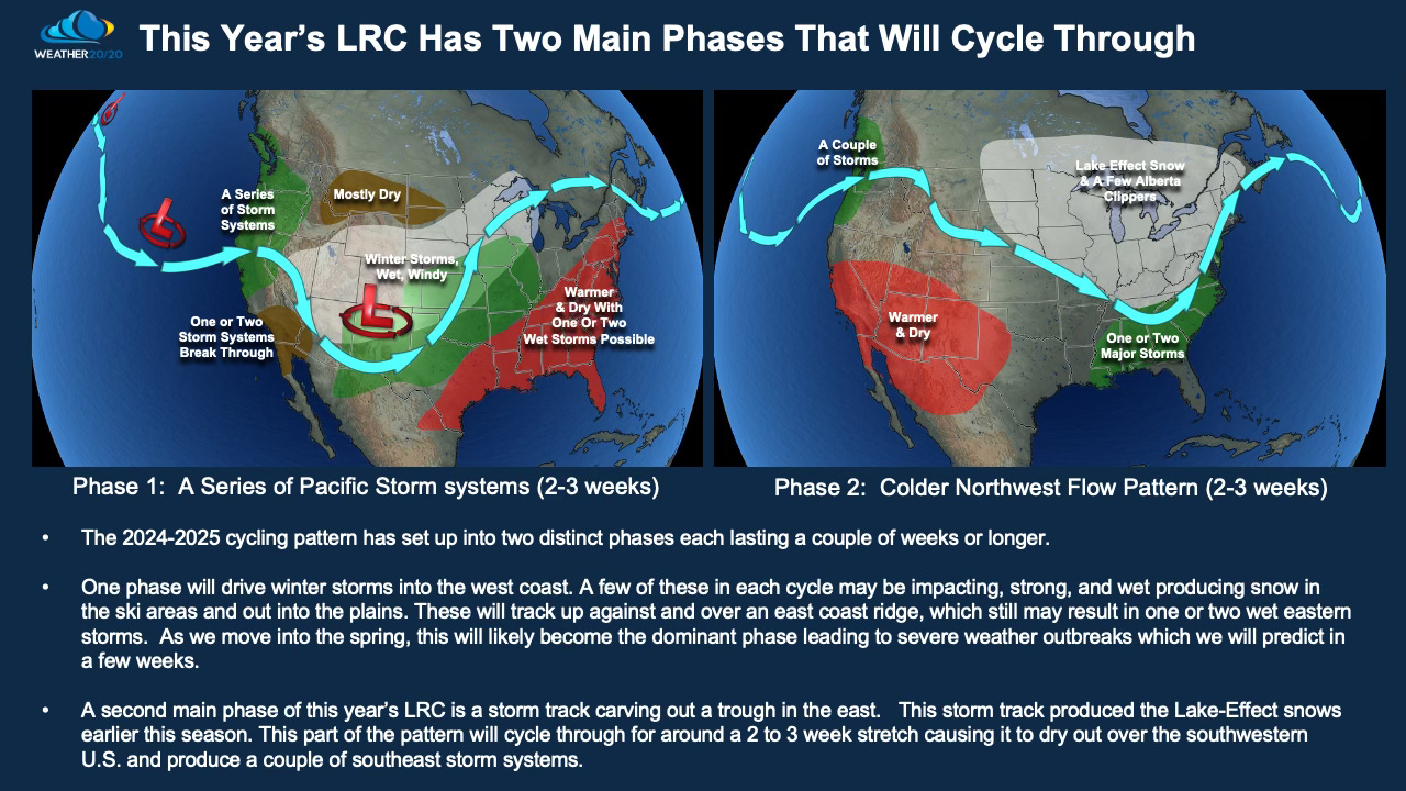
The weather pattern across the Northern Hemisphere has two main phases of this year’s LRC. Phase 1 is in motion now and it is going to transition into Phase 2 by around January 10th. Before this transition happens, a series of storm systems will affect the United States with one of the stronger ones possible January 5th - 7th. Let me show you the first exhibit of this year’s LRC by looking at cycles 1, 2, and 3.
Watch today’s video as I showcase the three cycles, and then I will continue with the explanation below:
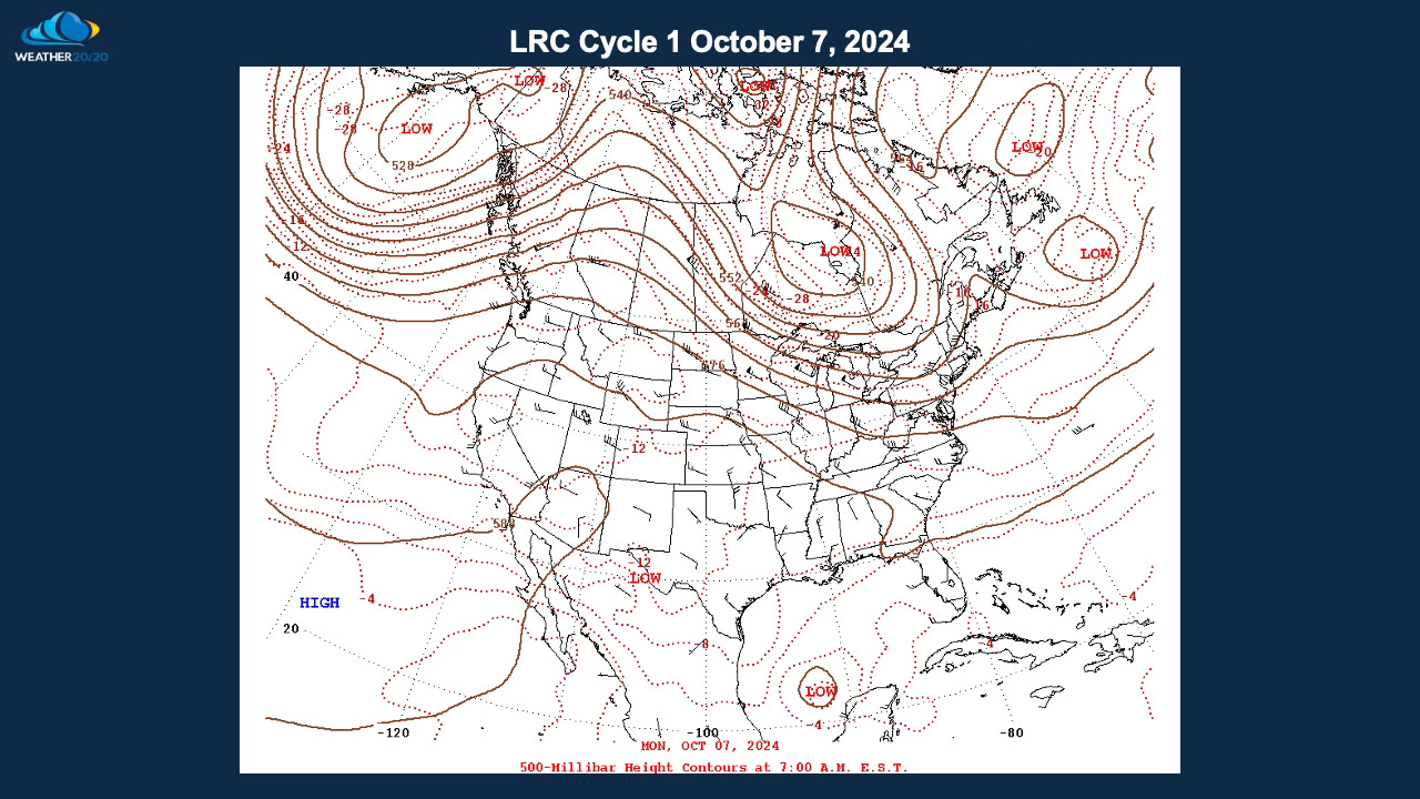
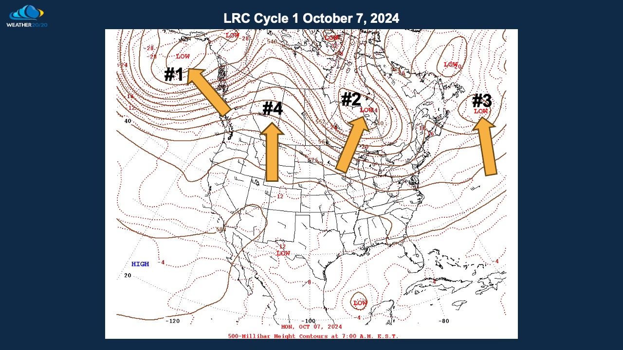
The 500 mb level of the atmosphere is around half way up in weight. The top of the atmosphere has no weight at all, and the surface, where we all live, has around 1013.25 mb of pressure on us at all times, give or take a bit when a storm with low pressure moves across or a high pressure area moves in. This half way point is around 18,000 feet above us. The winds blow parallel to these height lines as you can see below:
This first map above, and the one below, shows the flow on October 7, 2024, or right at the very beginning of this year’s LRC. I labeled some of the big features from #1 to #4 showing three troughs/upper lows, and one big ridge.
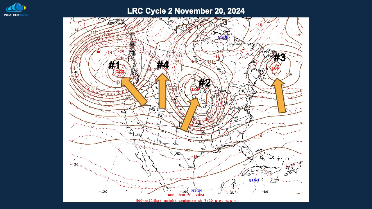
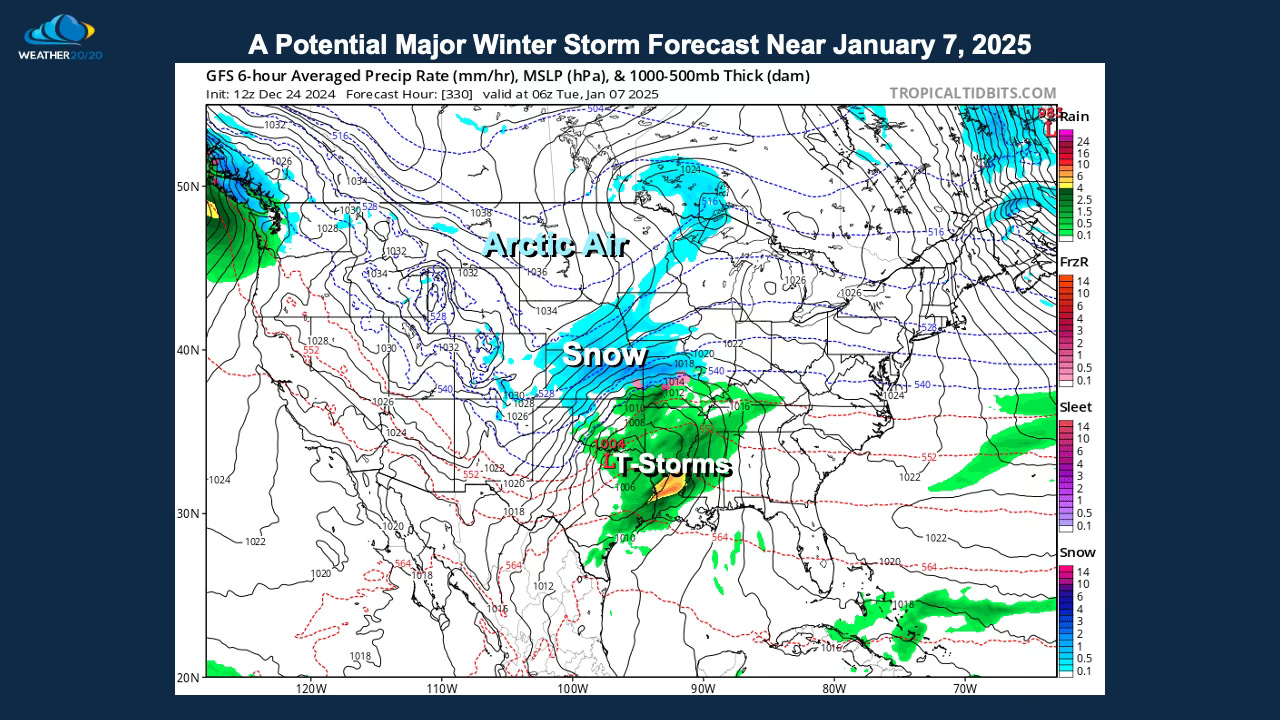
The map above shows October 7th, and then this map below shows that the weather pattern has cycled back through on November 20th. And, then the following map shows a forecast of the weather pattern for around January 2nd, three to five days before the potential major winter storm forms.
Compare the last three maps showing October 7, November 20, and the forecast for January 2. It’s the first, “you can’t make this up” revelation of the season.
What happens a few days later is going to be fascinating to watch unfold. That feature #1 on the January 2, 2025 forecast, is predicted to ride in and potentially interact with some Arctic air. The Arctic Oscillation is potentially going to dip deeper negative to near -3 around in the next two weeks. This will likely be a great exhibit of our first true 2024-2025 LRC prediction for a specific storm.
The models will likely show a storm, then they likely will not show a major storm, but then when we get with five to seven days I am expecting this combination to develop into a Major Winter Storm. Here is one possible example shown below:
What is the probability of a strong system organizing as I just discussed? We now know enough about this year’s LRC to predict that there is a 90% probability a Major Winter Storm will form. What is the probability you will see snow from this storm; thunderstorms from this storm; or get missed entirely by this storm? For Kansas City, I put the probability at 50% that this storm will impact your local area with winter effects with all types of precipitation possible. We will learn a lot more in the coming days.
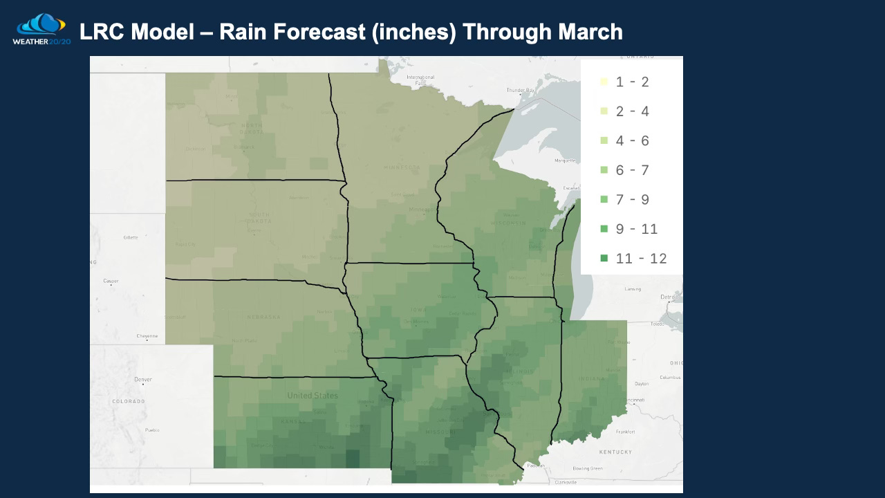
If you own a farm or a weather sensitive business we highly recommend you adding the Weather 20/20 Vision Dashboard to your weather forecasting tool chest. Here is a map I created showing the updated prediction for melted down snow and total rainfall between now and the end of March:
The LRC model just updated on December 22nd, and it will become increasingly accurate in the weeks ahead to help you plan for planting, growing, and harvest in the months ahead of us.
When you watch the video, I really went slowly through the map-to-map comparison, the art of meteorological science, to showcase an exhibit of this year’s cycling weather pattern. It is absolutely fascinating to me, and I hope you find it fascinating as well.
By next week’s report, we will have much higher confidence on whether or not that winter storm will be developing. Well, I already said I am 90% confident, but exactly how it forms and tracks will decide what will happen where you live.
Happy Holidays! Thank you so much for being on this journey of discovery together as we provide valuable information for your decision processes!
Gary





I look forward to reading the updates on the winter storm based on the LRC.