Hurricane Season Begins — What To Look For
Traditional Hurricane Season begins on June 1st each year, even though there are often earlier named storms in May, and this year there was yet another one when Subtropical Storm Ana formed over the open waters of the Atlantic Ocean. There has been some discussion by my science peers in meteorology to start hurricane season around the middle of May to compensate for these early named systems. This would be fine with me, but what is missing is the understanding of the LRC.
Hurricane season actually begins in the fall when the LRC sets up each year. It then goes dormant, and then re-emerges in the late spring and summer months.
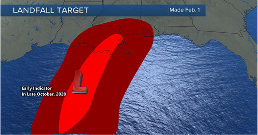
We issued our tropical outlook in February, and we are monitoring closely for any early development. If there is minimal development in June, this will lean strongly towards a quieter season ahead. Now, if June becomes active, even with one or two early named systems, then this is a strong indication that it may be active as is the forecast in most predictions.
The two forecasts above show a part of the LRC that will be cycling through in the next four weeks. These are two of our targets that will cycle through later in June. There are three LRC cycles in this year’s hurricane season, and the May-June cycle is the least likely cycle for named storms to form, due to the fact that the water temperatures are still warming up. And, there is still some shear from the westerly belt. The jet stream will be retreating as summer approaches and the water will be warming up. Conditions will become increasingly favorable for tropical systems and the LRC provides the technology to know when and where they are most likely to develop.
If you are interested in more specific information, please contact us through the website.


