


The National Oceanic & Atmospheric Administration (NOAA) issued their winter forecast today, October 20, 2022. It is way too early to issue a long-range prediction, but this doesn’t even get specific anyway. Let’s take a look, and watch the video for some more points!
Last Year’s NOAA Prediction Verifications:
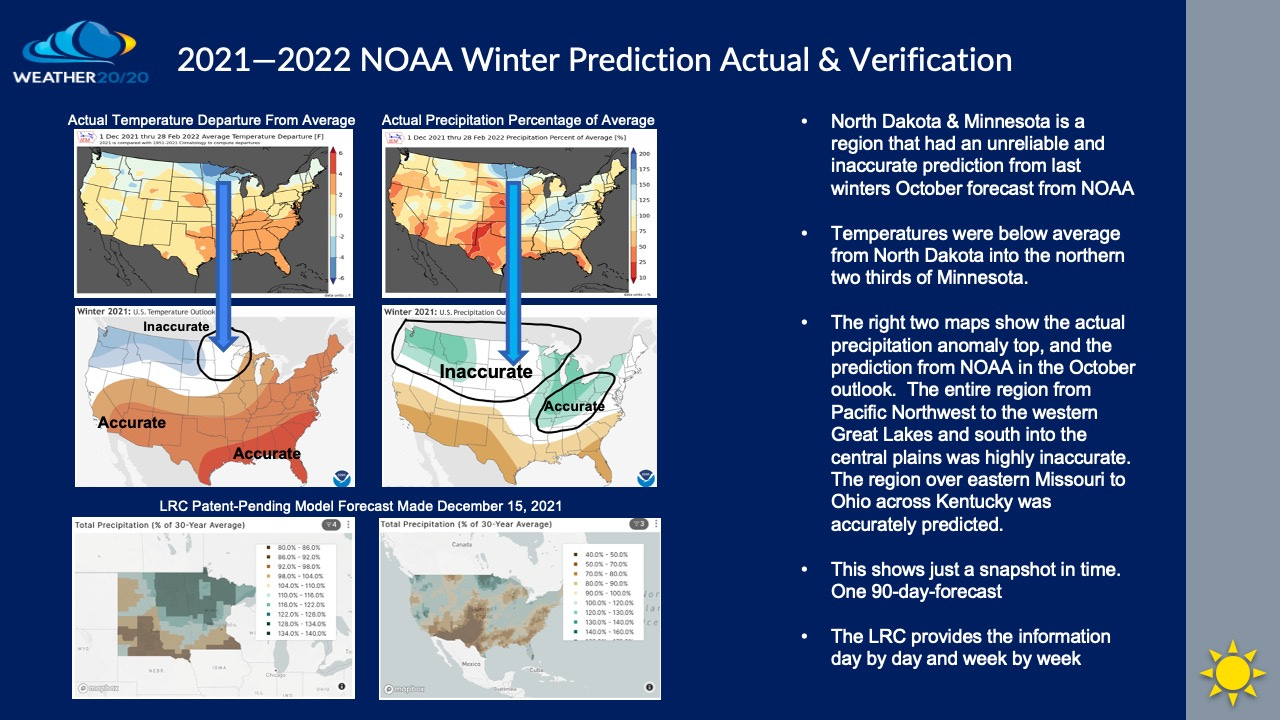
The first big takeaway from this type of long-range-forecast is that it is one snapshot in time for a 90-day-stretch. i.e. In Minnesota and North Dakota the forecast was for near average precipitation and near average temperatures.
In Minnesota NOAA did not predict the highest anomaly for rain and snow last winter, and for the coldest region over northern Minnesota. The LRC model did predict these conditions, but we had to wait until December to make this prediction last winter. NOAA does not even take into consideration the centerpiece of the big atmospheric puzzle, and what we share with you from Weather 20/20: The LRC!
We are currently in the third year in a row of La Niña, which is the cooling of the tropical Pacific Ocean. When we get five consecutive 3-month averages of -.5°C or lower we call it a La Niña event. We have now been in a La Niña for 23 of the past 25 3-month-average periods:
Red is El Niño & the blue shaded dates show La Niña

It is now likely that we will begin this winter season with a third consecutive La Niña influence. We are currently analyzing other third La Niña years and what it means for each location around the world. One thing we have tested and it is in our peer reviewed paper “Cycling patterns of the Northern Hemisphere”, is that La Niña is definitely a strong influence on the seasonal outlooks, but it is still only an influence on something much bigger. Weather 20/20 knows when and where winter storms, tropical storms, drought, floods, severe weather outbreaks, and 90% of the major weather disasters will happen.
This is how Weather 20/20 made this following prediction for the hurricane season:
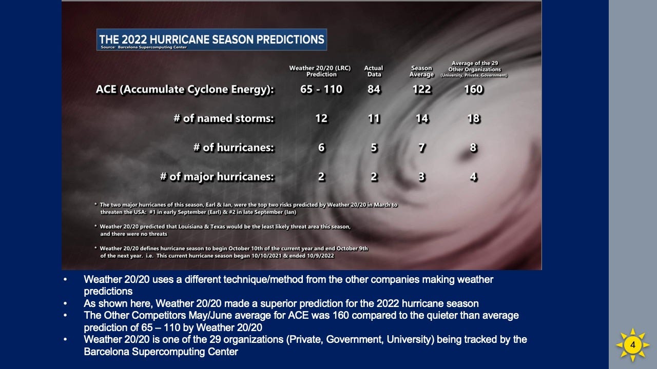
As you can see above, Weather 20/20, LLC just threaded the needle once again, by predicting the parameters being tracked by the Barcelona Supercomputing Center site. Our ACE (Accumulated Cyclone Energy) prediction of 65-110 this season had it pegged as a below average season. The 29 other competitors actually had a prediction of 180 at one point as the season began, and then reduced it to 160.
NOAA FORECAST FOR THE 2022-2023 WINTER
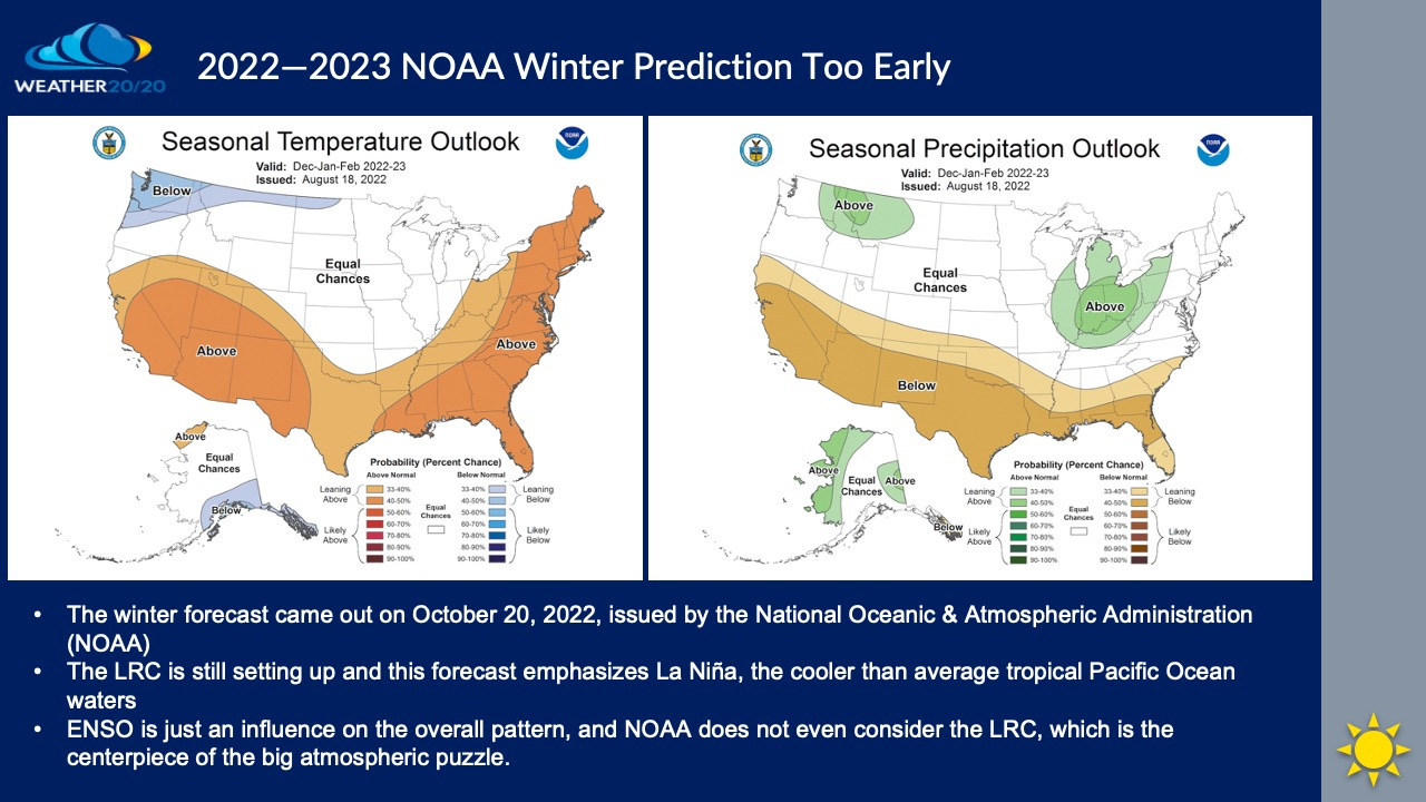
Again, this forecast shown above only provides a snapshot prediction for each location. For example, in Kansas City, where I live, this forecast means that there are equal chances of above, average, or below average temperatures and precipitation. This is all this provides.
Weather 20/20 will provide the specifics, day by day, week by week, month by month, 90-day, and 6-month outlooks for 2023.
Right now, a storm may be in the process of becoming one of the signature storms of the season, with some severe weather risks, winter storm risks, and more. Let’s see how this evolves. I can’t stress this more: The pattern is still evolving right before our eyes. The seeds of this winter forecast are being planted now. The seeds of next hurricane season are just going into the “ground”.
Be sure to join the pay version of this newsletter/substack account at the 50% discount rate of $300/year, or join for $50/month. We will be sharing the patent-pending LRC-Model data with you this winter and as we move into 2023.
Have a great end of October. I will be updating the paid version for our customers in two weeks with an initial look at the model data.
Gary Lezak

Share this post