Weather 20/20 Weather Intelligence Report: The Dawning of a New Weather Cycle
Late September Report On The Sun Setting At The North Pole
Dear Weather Enthusiasts and Industry Professionals,
As the sun sets over the North Pole—an event of astronomical significance—we find ourselves on the cusp of a compelling metamorphosis in our atmospheric landscape. This annual solar event, which leads to total darkness at the North Pole, intriguingly coincides with the genesis of a unique weather pattern that will govern our climate for the next year: the Lezak Recurring Cycle (LRC). While we continue to explore the scientific intricacies of this relationship, the coincidental timing suggests a mysterious and profound interconnectedness between astronomical events and our Earth's weather systems.
Add here
A Look Back at the Year That Was
The past year's LRC cycle has given us much to talk about, and as always, its impact has been far-reaching. From historic snowstorms on January 4th and February 23rd that blanketed the Twin Cities in Minnesota to devastating tornadoes in Mississippi and Texas, the LRC has played a hand. Hurricanes Hilary and Idalia, along with tropical storm Ophelia, made their presence known with landfalls in the United States. We even witnessed the rapid dissipation of a crippling drought in California within a few months last winter.
All of these significant weather events are not random occurrences; they are woven together by the threads of the ever-cycling LRC.
Here is today’s video explanation:
In the slide above, you’ll see a timeline chart that outlines the progression of the LRC from October through the following September. As we embark on the next few critical weeks, keep an eye on the evolving atmospheric conditions. This period marks the birth of a new, unique weather pattern that will guide us through the coming year. Once his pattern is established and completes its first full cycle, we’ll engage our patent pending LRC model. This groundbreaking tool will enable us to offer highly accurate, long-term weather predictions, customized to various industries and activities, based on the newly identified cyclical pattern

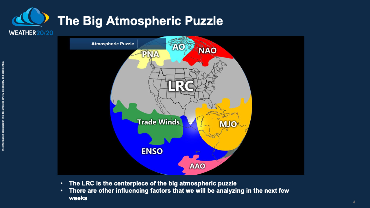
The Lezak Recurring Cycle (LRC) serves as the cornerstone in a complex atmospheric puzzle that shapes our weather. While the LRC plays a pivotal role, it's important to recognize that there are additional influential factors. For instance, as illustrated in the accompanying graphic, we're currently witnessing an intensification of El Niño conditions over the tropical Pacific Ocean.
The latest ocean temperature readings from the tropical Pacific Ocean have just been released today, and they're capturing everyone's attention. Clocking in at 1.7°C above average, we're experiencing some of the warmest conditions in years. For an El Niño event to be officially declared, we need to see five consecutive 3-month averages at least +0.5°C above the norm. We've already notched three, and the fourth is set to be confirmed next week. This means that by the end of October, there will be plenty of chatter about the upcoming El Niño winter. But let's exercise some caution here. As we discussed in our published paper, "Cycling Weather Patterns of the Northern Hemisphere," the reality can sometimes diverge sharply from conventional El Niño expectations. Stay tuned, as the LRC will be shedding light on what's actually in store over the next couple of months.
Rainfall From September 16-25, 2023
As you glance over the rainfall data from the past ten days shown in the graphic above, and the forecast for the upcoming ten days displayed below, it's important to keep one critical point in mind: We're currently in a transitional phase. The weather patterns you're seeing are primarily remnants from last year's cycle. In other words, don't mistake these recent and upcoming rainfall figures as a preview of the upcoming year. We're on the cusp of a significant shift, as the new Lezak Recurring Cycle (LRC) begins to take shape.
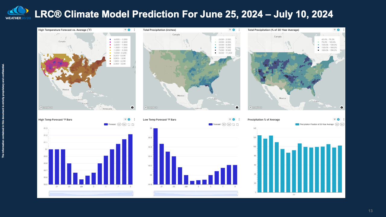
Displayed in the next three maps are our LRC model-generated predictions for January, April, and the period from June 25 to July 10. These projections offer day-by-day forecasts for the entire continental United States for these specific timeframes. It's crucial to note that these predictions are based on the current data and will serve as our baseline forecasts. Once the new LRC takes form, we'll revisit these models, comparing them to the newly established weather patterns. I've included the June 25 to July 10 stretch specifically to address the needs of our customers who have a keen interest in the July 4th holiday period.
In summary, this report offers a glimpse into the fascinating world of long-range weather forecasting through the lens of the Lezak Recurring Cycle (LRC). As we stand on the cusp of a new weather pattern, we've shared insights into past and current conditions, as well as projections for the months ahead. This report is being disseminated to our thousands of valued customers as a testament to our commitment to providing actionable weather intelligence. For those interested in diving deeper, we highly recommend our premium reports. Priced at just under $1 per day, or $300 per year, our premium subscription provides exclusive access to in-depth analysis and insights into the developing new LRC. Your investment empowers you with the weather intelligence you need to make informed decisions year-round.
Welcome to fall! Let us know if you have any questions.
Gary Lezak


Hi Gary, in Louisiana, we are currently experiencing salt water intrusion into the Mississippi River where many get their drinking water. They tell us that this is due to the drought in the upper Mississippi valley and that we need to see 10 inches or more up there in order for the fresh water to make it to us. Do you foresee that amount of rain in that area anytime soon?