


May Rainfall Patterns: Planning For The Next Ag Impact
The cycling pattern is right on schedule. What is next on the weather blueprint?

Welcome to this week’s Weather 20/20 Intelligence Report — and as we move through mid-May, the recurring pattern we’ve been tracking all season continues to show up right on schedule. This is a crucial time for the agricultural community, and the LRC gives us a unique edge: not just in knowing what weather is coming, but when and where it will matter most.
In this report, we’ll highlight the next impactful precipitation windows, examine how this cycle aligns with earlier rounds of severe weather, and outline what farmers should watch for in the final stretch of planting and early crop emergence. Timing is everything in agriculture — and this week, the pattern is delivering signals worth paying attention to.
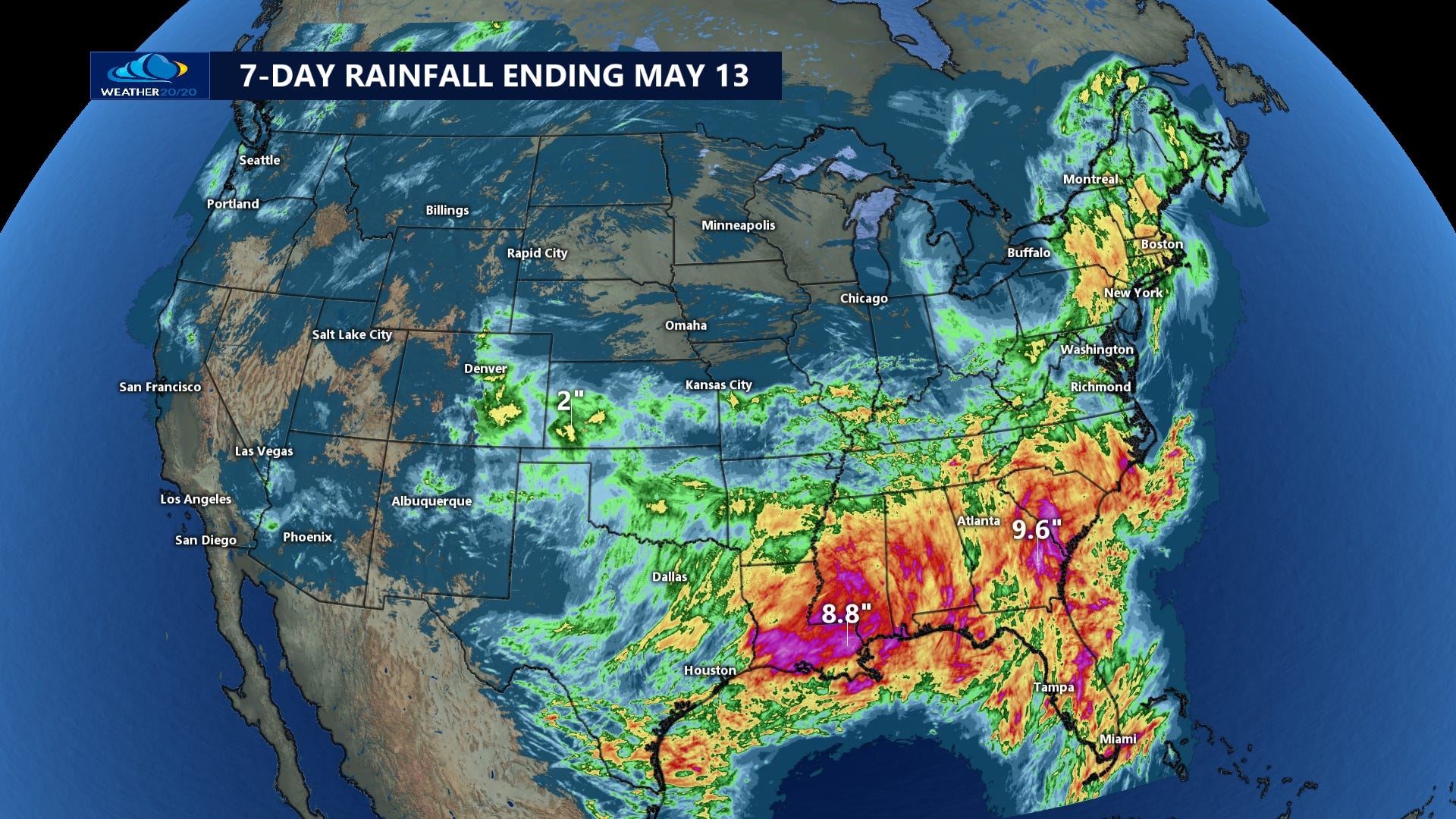
The first two graphics show rainfall totals from the past week, which brought a well-timed dry spell across much of the central U.S., particularly north of I-70, where conditions remained mostly dry. Meanwhile, Western Kansas and areas farther south saw beneficial moisture. With most of the planting already completed, this dry window came at just the right time — and as forecast using the LRC.
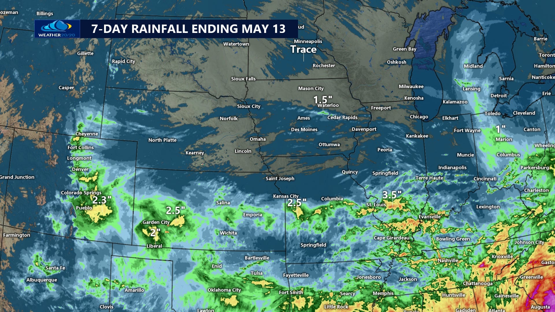
Now, as we head into late May and early June, we are entering the next stormier and wetter phase of this year’s recurring cycle. As predicted weeks ago, this period will likely bring multiple precipitation events, with potential impacts on early crop emergence, field access, and disease pressure. The pattern is evolving right on schedule — and we’ll break down what that means for your fields in the sections ahead. On this map below, we can see the beneficial rainfall that finally targeted western Kansas.
The next two weeks will be fascinating to watch unfold. There are many rainfall forecast solutions from the various models and here are two of them, but first, here is today’s video:
Winter Wheat
May is a critical development month for winter wheat, especially in Kansas, Oklahoma, Texas, and parts of Colorado. Crops are either in heading or grain-fill stages, which means moisture is essential — but too much rainfall or prolonged saturation can introduce new challenges:
Benefits:
Well-timed rain improves yield potential by supporting grain fill
Reduces crop stress in dryland fields that struggled earlier this spring
Risks:
Persistent moisture may increase the risk of head scab and rust diseases, particularly if storm systems coincide with flowering
Delays in dry-down can postpone harvest and introduce quality concerns in low-lying or poorly drained fields
Western Kansas, one of the drier regions this season, just received some beneficial moisture, improving short-term conditions. However, a potential drying period is approaching, and producers in that area should monitor closely for signs of stress resurgence, particularly in non-irrigated fields.
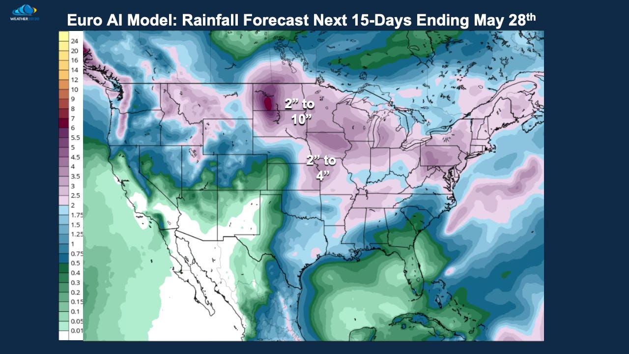
Meanwhile, farther north, a remarkable alignment is emerging between both the GFS and the European AI-enhanced forecast models, showing 2" to 10" of rain across the Dakotas in the coming two weeks. This reinforces what the LRC has already suggested — that we’re entering a stormier phase with elevated precipitation risks across key growing regions.
Here are the latest forecasts from these two models:

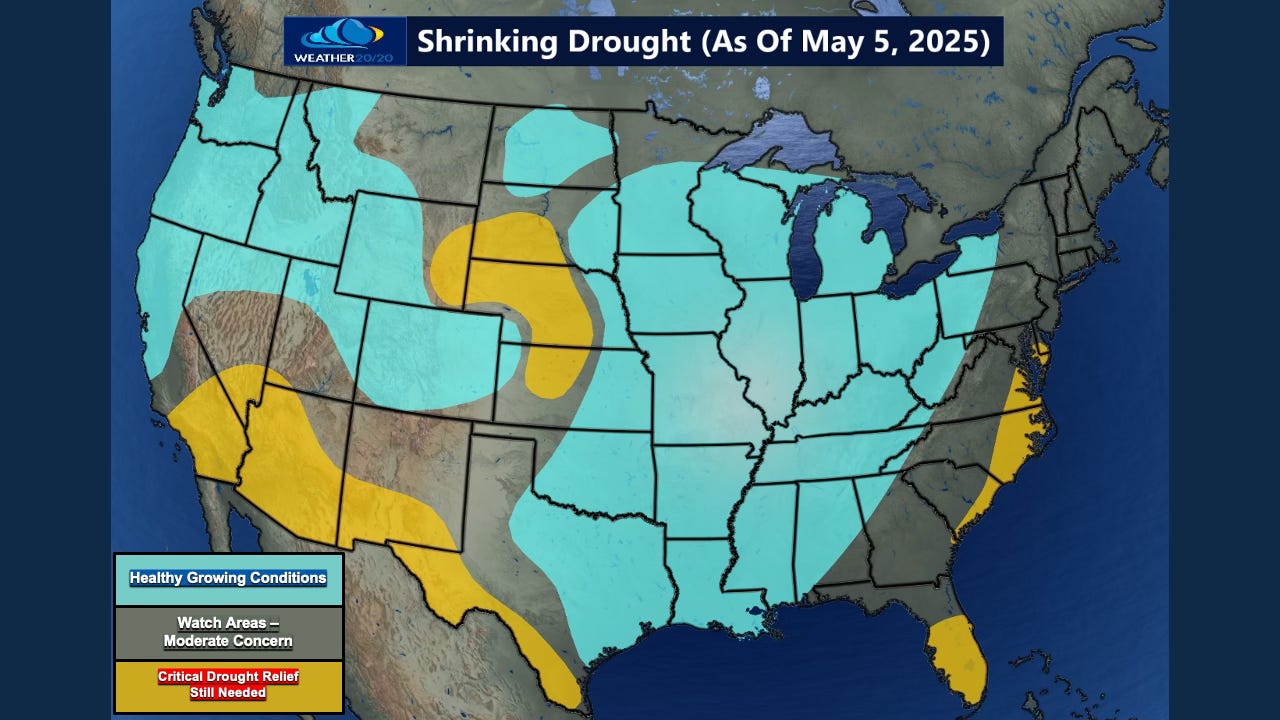
Targeted Drought Relief Still Uncertain over parts of Nebraska and South Dakota
One important trend to watch in the latest rainfall forecasts is how precipitation aligns with areas we’ve highlighted for drought concern. The core region still facing critical drought conditions is also the one area where rainfall totals remain lower in the short- and medium-range outlooks. While adjacent areas are projected to receive meaningful moisture, this pocket continues to show up on the drier side in both the GFS and ECMWF model guidance.
We'll continue monitoring this region closely in the coming cycles. As always, the LRC provides us with advance awareness of potential opportunities — and gaps — in precipitation that traditional models often overlook.
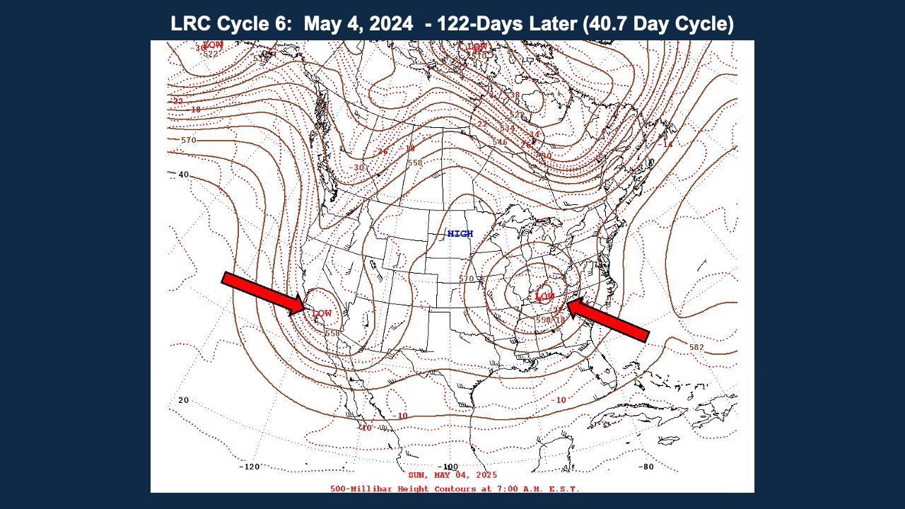
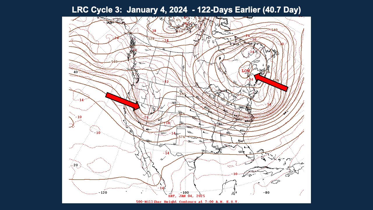
Jet Stream Shift & Seasonal Transition: The Pattern Continues
Last week, we showcased a map-to-map comparison that highlighted how remarkably on schedule the current LRC cycle remains. Here are those two maps again as a powerful reminder of the consistency and predictability of this year’s pattern.
As we approach summer, one key transition is already underway: the weakening and northward shift of the jet stream. While this shift typically becomes more pronounced in late May and June, the process actually began subtly in February and March. We're now seeing more obvious signs as the atmosphere transitions toward its summer configuration.
The energy is still strong enough to produce potential major severe weather outbreaks and tornadoes well into June, with these risks fading as summer begins. There is still severe weather over the summer, but just not usually as organized, as wide spread, or as deadly as earlier in the spring.

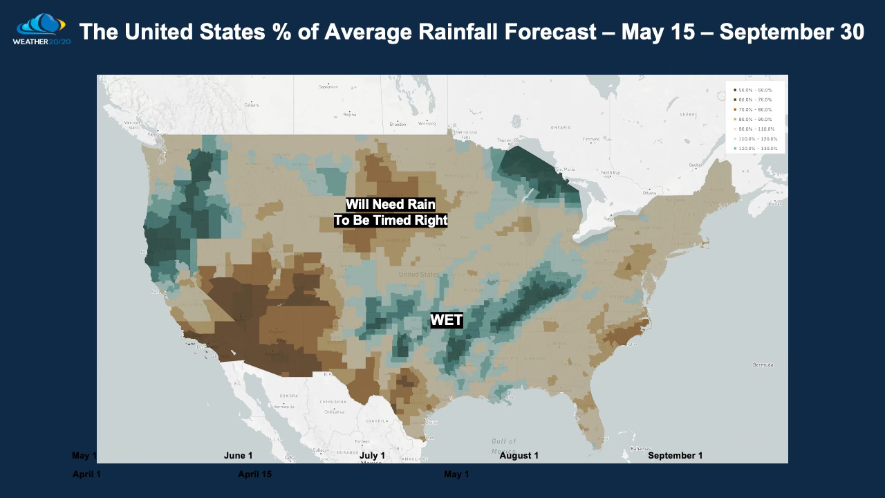
The region forecast by the LRC model to be a bigger concern for drought may get some significant moisture in the next two weeks, so the timing may be just right.
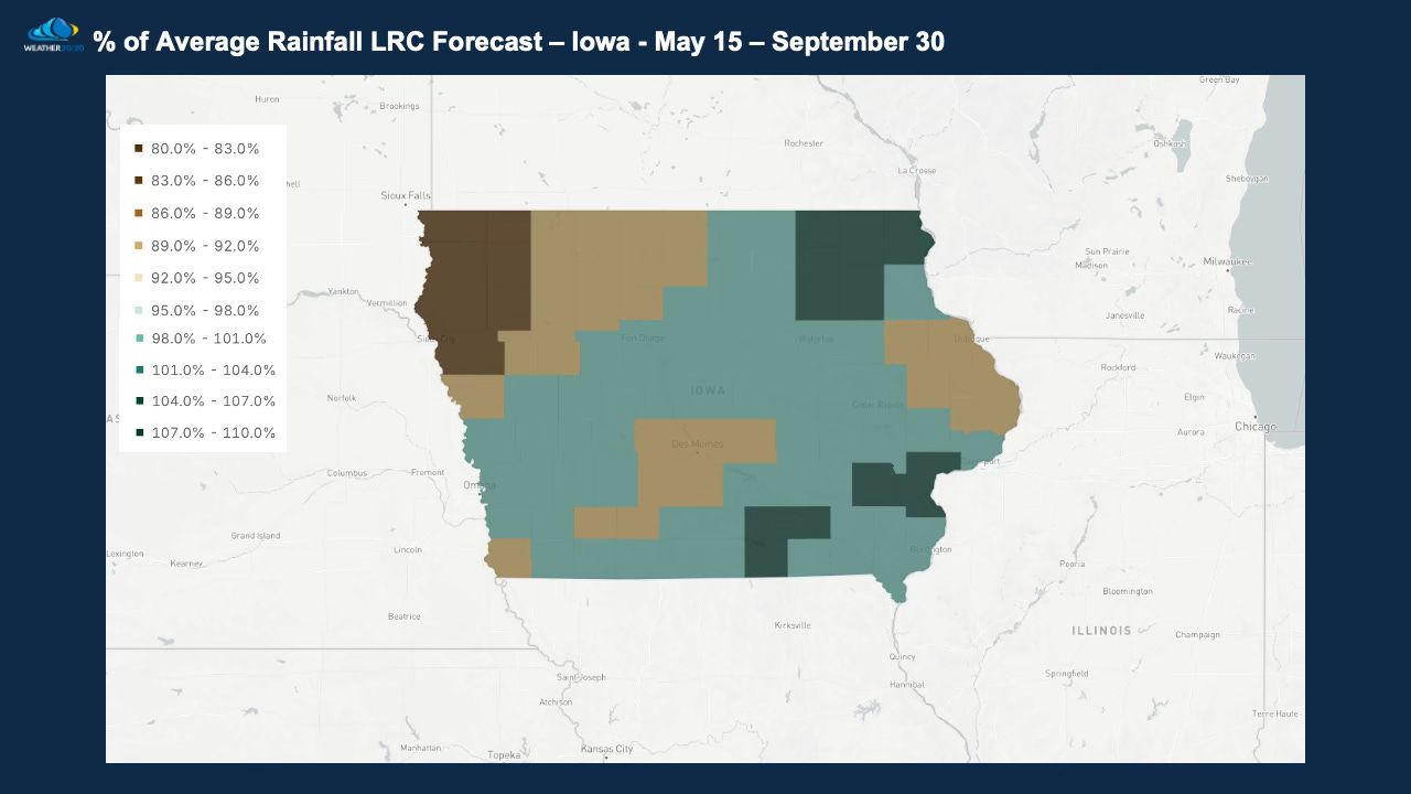
Let’s focus on Iowa, shown below, where most of Iowa is forecast by the LRC model to have near average rainfall through September, and again it will come down to the timing of the western storm storm systems and dry spells:
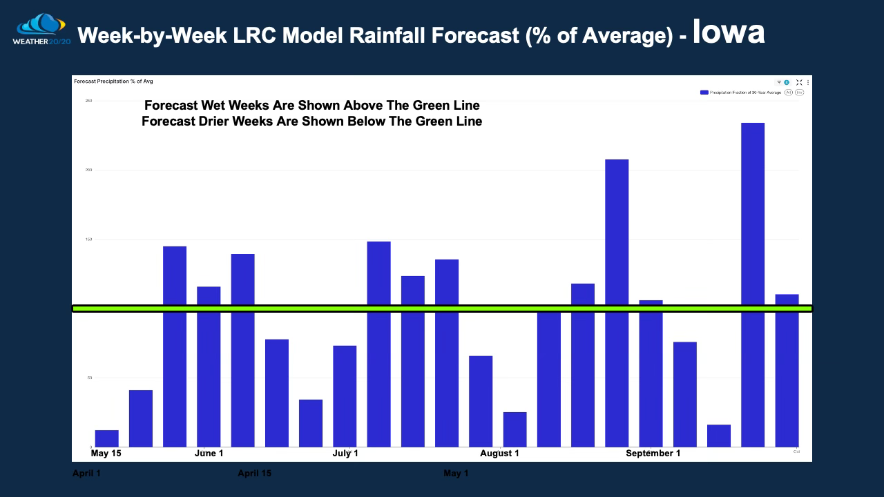
In the week-by-week analysis we can see the wetter three week stretch is just around a week to ten days from getting started.
As we move through mid-May and into the heart of the growing season, the LRC continues to provide clear, actionable insight into what lies ahead. From the recent dry spell that aligned perfectly with planting progress, to the stormier window now developing — the pattern is unfolding exactly as forecasted.
With the jet stream weakening and shifting north, the focus of impactful weather will transition with it. But thanks to the LRC, we are not reacting to these changes — we are planning around them.
Whether you're monitoring soil moisture, scheduling fieldwork, managing harvest windows, or adjusting feed strategy, Weather 20/20 is here to provide the most accurate long-range guidance available. We'll continue tracking this pattern closely to help you stay one step ahead.
Have a great week!
Gary Lezak

Ben, your "just enough" statement hits it on the nose. The pressure is on each chance of rain, and we will feel that pressure early next week. There will be many other chances as phase 1 of the pattern cycles through in the next four weeks. Keep us updated.
I’ve had 5 inches in North MO going back about 75 days or so. We’re falling behind but have had just enough to keep us going. Most of the planting will be finishing up by the weekend but we’re running out of moisture to plant into. Everyone is hoping the rain comes on Monday